

Dr Nial Moores, Director Birds Korea / 새와생명의터, Busan, March 2nd 2024. Posted online in August 2024.
Executive Summary
- As proposed, a new international airport will be constructed at the southern end of Gadeok Do in Busan by 2029. The formal Strategic Environmental Impact Assessment (posted online by“EIASS”) conducted by the Ministry of Land, Infrastructure and Transport for the proposed airport was published in August 2023 (MLIT 2023) and contains information on birds gathered through different research approaches between November 2022 and July 2023. This information is then used by development proponents to try to assess the impacts on threatened bird species and also the potential risks of bird strike if the new airport is constructed as proposed.
- Although MLIT (2023) contains a lot of information on birds within a 13km radius of the proposed airport, data are not interpreted in ways that facilitate an assessment of the likely impacts on biodiversity at the national or regional level.
- In addition, with the exception of 15 dates in May of survey of six species of raptors >1km from the proposed runway, there is no research in MLIT (2023) which can be used to assess either the scale of bird migration through the proposed airport area or provide an evidence-based assessment of bird strike risk.
- Gadeok Do is an island in the southeast corner of the Korean Peninsula adjacent to the shortest sea-crossing used by birds migrating between Korea and Japan. This southeast corner of Korea is an integral part of the East Asian-Australasian Flyway. Although robust data are lacking, perhaps millions of birds migrate between Korea and Japan every year through southeastern Korea.
- Omitted from MLIT (2023) is the recognition that Gadeok Do is oriented on a north-south axis, widest in the north, narrowest in the south, with the highest hill peak (Yeongdaebong) in the south. Based on research elsewhere, Gadeok Do’s physical geography can be expected to concentrate and funnel a wide diversity of birds during migration. This includes large soaring birds which often seek out highest hill peaks in search of air currents and thermals to help gain altitude for flight over sea; and species which follow coastlines.
- As recognized explicitly in MLIT (2023), tracking confirms that several large soaring species migrate regularly between Korea and Japan across the Geoje/Busan-Teima Do (Tsushima)-Kyushu sea-stretch, some of which use Yeondaebong in southern Gadeok Do to gain height. Direct observations from various locations in Busan and on Tsushima / Teima Do confirms that large numbers of many bird species migrate regularly through this migration corridor.
- To assess visible bird migration through the proposed airport area, we conducted fixed point counts of migrating birds for 64 hours and 30 minutes spread across 11 dates in Daehang, Gadeok Do, between September 2021 and February 2024.
- Our counts recorded 10,933 individual crossings by a total of 68 species over the proposed runway area at a mean rate of 2-3 individuals per minute. Among species of highest conservation value and also of highest risk to aircraft were more than 3,110 individual raptors of 13 species.
- Limited research conducted to date confirms that in addition to the internationally important Nakdong Estuary to the east which is well-covered in MLIT (2023), the Geoje Island Coast to the west also supports large numbers of migratory waterbirds, including many of the same bird families implicated elsewhere in bird strikes, both during migration and in winter.
- To reduce impacts on avian biodiversity and to assess the risk of bird strike during operation, substantially many more dates of fixed-point counts in the proposed runway area are urgently required, especially during the main migration periods, supported by bird radar studies.
- Background to the Report
This report expands on a condensed summary of counts of birds undertaking migration across the proposed runway area on Gadeok Do, Busan (Figure 1). The summary was presented by the author to a press conference in Seoul organised by KFEM in May 2022. As information in the summary was only alluded to in an opinion listed on p. 120 of the Strategic Environmental Impact Assessment (MLIT 2023), this report provides more detailed results of the original seven dates of counts (between September 2021 and May 2022) and an additional four dates of counts (in October and November 2023 and in February 2024), all made from the same “fixed count point” in Daehang Village, Gadeok Do.
If they are to be useful to non-specialists (e.g., to decision-makers, local people, NGOs and media), count data need to be interpreted honestly and put into an appropriate context. This report therefore aims to help interpretation of our 11 dates of counts (presented in Section 2) by providing background information on: (1) the relationship between geography and bird migration through Gadeok Do (Section 1.2); (2) international best practice in assessing bird strike risk, based on ICAO (2020) (Section 1.3); and (3) some of the flaws in the research on birds and its presentation in MLIT (2023) (Section 1.5 and Concluding Remarks). Finally, we use our data to provide an initial evidence-based assessment of bird strike risk in the immediate vicinity of the proposed runway area (Section 2.2.3 and Appendix Two).

- Gadeok Do: Geographical Location and Bird Migration
Bird migration is seasonal movement shaped at a range of scales by climate and geography. During migration, many waterbirds depend on chains of wetlands found along coasts and major rivers; while many landbirds try to avoid unnecessarily long sea crossings.
Gadeok Do is situated between the island of Geoje Do to the west and the Nakdong Estuary to the east in the southeast corner of the Korean Peninsula. Gadeok Do is therefore situated directly adjacent to the shortest sea-crossing available to birds migrating between the Republic of Korea (ROK) and Japan via the Japanese island of Teima Do / Tsushima 60km to the southeast.
In addition, Gadeok Do is a narrow 9.6km long island which is more or less oriented on a north-south axis and is therefore likely to “funnel” and concentrate birds during migration. The island also has several hills which can be used by soaring birds to gain height before attempting a sea crossing or to regain height after crossing water. The highest hill is Yeondaebong in the south of the island, with a peak of 459m. This peak is situated c. 1.2km north of the northern edge of the proposed airport (Figure 2), and was selected by EIA researchers to conduct fixed point counts of raptors in May 2023 (MLIT 2023). The generalized rationale behind the importance of Yeongdaebong to migratory raptors can be found in the global review of soaring bird migration by Chiatante et al. (2022):
- Soaring bird species migrate by exploiting vertical winds (thermal and orographic updrafts), which mostly form over land and especially along mountain chains, which constitute migratory “highways” when aligned along the axis of migration;
- As uplifts are invisible, some soaring species tend to migrate in flocks, probably using social information to increase their probability to locate vertical currents;
- Uplifts are weak or absent over water; therefore, obligate soarers are known to try to avoid long sea crossings and to concentrate close to narrowest sea-crossings at “migration bottlenecks.”

The geography-centric importance of the southeast corner of Korea for birds migrating to and from Japan and further along the East Asian-Australasian Flyway was long suspected (e.g. by Gore & Won 1971) and was fully confirmed through satellite tracking more than 30 years ago (Higuchi et al. 1996; MLIT 2023). Direct observations elsewhere continue to confirm that large numbers of birds cross the Korean Strait to and from this southeast corner of the ROK. This includes e.g., 78,955 Chinese Sparrowhawks Accipiter soloensis recorded in September 2021 at one count point in southern Teima Do (Tsushima) (http://www5b.biglobe.ne.jp/~nojiko/watari21.html); presumably all of the thousands of globally Vulnerable White-naped Cranes Antigone vipio and Hooded Cranes Grus monacha wintering in Kyushu (see e.g. Higuchi et al. 2004; Mi et al. 2018); flocking species like Rook Corvus frugilegus; and many additional species of waterbird and landbird.
Furthermore, we hypothesized that Gadeok Do might also be used by birds migrating along the south coast of Korea between China-Korea and China-Korea-Japan (a migration route described in Moores 2012; and indicated by tracking studies of Crested Honey Buzzard Pernis ptilorhynchus shown in MLIT 2023). During northward migration, this route would be taken by birds migrating through Gadeok Do to points to the east and north, and during southward migration it would be taken by birds going through Gadeok Do to Geoje Island and points to the west and southwest (Figure 3).

1.3 Assessing the Bird Strike Risk
Our research aimed first to assess whether or not Gadeok Do is used by large numbers of migratory birds. If it was, we then aimed to provide an initial assessment of bird strike risk. Bird strikes (collisions between birds and aircraft) are a widespread problem involving financial loss to commercial, civil, and military fleets worldwide as well as being a source of mortality for birds and more rarely for people (Fernández-Juricic et al. 2018; Andrews et al. 2022). Research related to bird strike therefore forms an essential component of the development of airport Wildlife Hazard Management Plans, as mandated by ICAO (2020).
An unknown number of cases of bird strike involving small birds away from airports go unreported. With this caveat, a global review of bird strikes by Metz et al (2020) found that larger-bodied birds and flocks of birds at higher altitudes tend to cause the most substantial damage during bird strike incidents. In addition, geographical location – and the resultant abundance of different bird species with variable behavior, size or tendency for flocking – was a key consideration in predicting the frequency of bird strikes and thus potentially the “safety risk” to aircraft. The same research also concluded that in regions situated along a migratory flyway, the danger of collision “remarkably increases” during migration seasons.
The safety risk to aircraft posed by bird strike is defined by the ICAO (2020) in Section 3.1.4 as the probability of a strike multiplied by the severity of damage caused. As noted in Section 3.3.2, “the severity scale will depend essentially on the size of the animal and its tendency to flock or congregate. Generally, heavier wildlife and greater flock size increases the probability of damaging an aircraft and impacting its flight performance. Flocking behaviour could include multiple impacts or increase the probability of a strike.”
Accordingly, ICAO (2020) provides clear guidance on the scope of research that is required to assess the safety risk as part of the development of a Wildlife Hazard Management Plan. Section 1.3.9 states that, “State authorities should analyse and approve the location of new aerodromes, to ensure that issues with high potential for wildlife attraction are considered and mitigated where necessary”; Section 2.2.4.6 clarifies that, “Wildlife surveys should cover the entire year to account for seasonal changes and should also consider different phases of the day. The survey should also consider aircraft movements, runways in use and wildlife behaviour. The greater the presence of hazardous wildlife, the greater the need to conduct surveys to gather information”; and Section 3.2.3 states, “where good quality strike data is not available, it is important to consider the potential risk of collision determined by the existence of wildlife and their movements on and in the vicinity of the aerodrome.”
ICAO (2020) therefore advises the construction of a risk matrix, in which “Different biological and behavioural characteristics of wildlife species can help classify them in specific risk Levels” (Section 3.2.9). Two criteria used as examples are mass, and flock size.
Despite the advanced stage of planning for the airport, in 2021 we were unaware of any research which had been conducted to assess the scale of bird migration through the proposed Gadeok Do airport site. If substantial numbers of birds migrate through this area, this would indicate a possibility of bird strike; and also suggest that many of the usual methods taken to deter birds from flying across a runway area might be unsuccessful. This is because movements of large numbers of birds would not be local and predictable; nor would they be made in response to the local quality of habitat in the proposed airport area itself. Instead, movements would be over much greater distances and would be shaped by major geographical features including e.g., mountain ranges, hill peaks, river valleys, coastlines and shortest sea crossings. In addition, the direction of flight, height of flight and number of birds would also be shaped by the combination of each species’ seasonal migration phenology and each hour by weather conditions important to bird migration, including visibility, wind direction at different heights, cloud cover, precipitation and changes in air pressure (e.g., Erni et al. 2005; Heinänen & Skov 2013; Chiatante et al. 2022).
ICAO (2020) Section 2.2.4.10, clarifies that, “There are many methods to conduct wildlife surveys. For example, wildlife observation points can be used to record the species seen and their behaviour during a clearly defined period of time.”
Accordingly, we made fixed point counts at a single wildlife observation point, located approximately 25m above mean sea level within 10m of 35.010550°, 128.829410. This observation point was selected as it is situated in the northwest of the proposed runway area (Figures 4 and 5); it overlooks Daehang Village, so effectively overlooks an open valley with a west-east orientation; and it provides clear views of Yeondaebong to the Northeast (Figure 6) and of Kuskubong immediately to the South-southeast. During our research, we aimed to identify each bird species; record the number of birds crossing over the northern boundary of the proposed runway; and collect data on bird behaviour (i.e., flock size, height of flight and flight direction) in a clearly defined period of time. Initially, we conducted seven dates of fixed-point counts from this roadside count point,
In this way, our geographical focus was on the part of the runway from which most aircraft would be expected to start take off. This is because 57% of all documented strikes happened during take-off and landing, 39% during climb and approach and approximately only 1% during en route flight for the observed period. The remaining 3% of all strikes happened during taxi and parking (Metz et al. 2020).


Our survey work confirmed that many birds migrated through Gadeok Do, including species which potentially pose a substantial bird strike risk (see Results below). The results of our research were therefore presented to national media on May 9th 2022 and were also posted publicly on various websites (including eBird, a global database maintained by Cornell University and on the Birds Korea blog at: https://www.birdskoreablog.org/?p=25834).
1.4 Gadeok Do Airport Strategic Environmental Impact Assessment (MLIT 2023)
In November 2022, research was started for the Gadeok Do airport EIA. The EIA report was published by the ROK’s Ministry of Land, Infrastructure and Transportation in August 2023 (MLIT 2023). MLIT (2023) compares three options for construction of the airport all on Gadeok Do; and suggests that the impacts of the current proposal (apparently selected before any of the research in 2022 and 2023) would be less than the impacts that might be caused by the two other alternatives.
As part of their support for this assertion, MLIT (2023) provides dozens of pages of information on bird counts conducted between November 2022 and July 2023 within 13km of the airport. This 13km outer limit was set in response to guidance from the International Civil Aviation Organization (2020) which requests the development of an airport Wildlife Hazard Management Plan up to a radius of 13 kilometers around the airport, and, if necessary, beyond. Importantly when considering biodiversity conservation, this guidance also advises that significant attractants—sources for food, water and shelter—should be removed and off-airport bird monitoring performed.
MLIT (2023) therefore provides maps showing the approximate location of records of threatened species up to 13km from the proposed airport area, and the movements of the individuals of some species as revealed by GPS telemetry. Much of the survey work was conducted within the adjacent Nakdong Estuary (between 6-7km and 13km from the proposed airport area). Little research was conducted in the proposed airport site on Gadeok Do itself; and no data are included from any fixed wildlife observation points within the proposed airport area itself, or even within 1km of the proposed runway area.
The clearest reference in MLIT (2023) to large-scale bird migration through Gadeok Do and the resultant potentially high risk of bird strike appears to be contained in a citizen’s opinion in Section 6-18 of MLIT (2023) (p. 120).
This opinion was based on our research between September 2021 and March 2022 which had been designed to respond to guidance provided by ICAO (2020) in Section 1.3.3, to “record wildlife presence (at a species level) on, and in the vicinity of, the aerodrome”; in Section 2.2.4.2 (f), to conduct “wildlife observations or surveys from the aerodrome’s vicinity taken periodically, at least seasonally and noting migratory activities”; and in Section 2.2.4.3, to record, “the type of wildlife activity and movements (for example: direction and altitude).” In accordance with this guidance, the opinion states simply that in order to assess the risk of bird strike, there is a need to know more about birds migrating through Gadeok Do. A handful of migratory species and bird families are listed as examples, and their expected months of migration are correctly listed as February 15th-end of May and again from August to December.
1.5 Important Weaknesses of the EIA Report (MLIT 2023)
(1) Inadequate scope of the research
ICAO (2020) Section 2.2.4.6 states that, “Wildlife surveys should cover the entire year to account for seasonal changes…the greater the presence of hazardous wildlife, the greater the need to conduct surveys to gather information.”
MLIT (2023) research covers only the period November 2022-July 2023.
Moreover, ICAO (2020) Section 3.1.2 states that, “The first step in a safety risk assessment of wildlife hazards is to define the area that will be assessed. This should include the entire aerodrome and its vicinity, in particular aircraft approach and take-off.” This is because in addition to the findings of Metz (2020) cited above, Dolbeer et al. (2015) also estimate that the vast majority (88%) of documented bird strikes in the USA over the past 27 years occurred below 2500 ft / 762m (with 71% below 500 ft / 152m). A European study of air traffic worldwide also concluded that 95% of bird strikes occur below 2500 ft / 762m (with 70% below 200 ft / 61m) (EASA 2009). Similarly, MLIT (2023) also contains references to literature and analysis that clearly identifies take-off and landing as especially prone to bird strike.
In spite of this, MLIT (2023) provides extraordinarily little information on birds found within areas which as proposed will be used for approach and take-off. MLIT (2023) is 2,440 pages long. In Section 9.1.1.-167 (page 902), all bird survey effort conducted for the EIA report is summarized. It includes up to 62 dates of survey of all birds in all habitats, extending up to 13km from the proposed airport; seven months of mapping tracks of birds using GPS Telemetry or some other method of tracking, including tracking ducks from a different project and 1-6 months of 50 birds tracked specifically for the EIA report (MLIT 2023, p. 991); and a total of 15 dates of fixed-point counts of raptors on migration.
None of the tracked birds were fitted with transmitters within the proposed airport area. Therefore, the only one of these methods designed to generate data on numbers, height and direction of birds potentially crossing over the proposed runway area itself are the 15 dates of fixed-point counts. These 15 dates were all in May, however (outside of the main migration periods for many bird species in the southeast of the ROK), and were made simultaneously at three points: 10km to the west on Geoje Do; on Yeondaebong, Gadeok Do, >1km north of the proposed airport; and in Taejongdae, a park 24km away in the southeast of Busan. These counts cover a total of only six species of raptor, and apparently of no other bird species.
This 15-day wildlife observation point effort did confirm the relative importance of Gadeok Do and Yeondaebong to migratory raptors in May, as a total of 517 raptors were counted at the three sites combined, and 406 of these (approximately 80%) were counted at Yeondaebong (pages 981-987). However, being so limited in time and scope, these counts, made >1km away from the proposed runway itself, are wholly inadequate for assessing the likelihood of bird strike in the vicinity of the runway itself, through an “entire year”.
Research effort included in MLIT (2023) that was made within the proposed airport area also appears to be incomplete or inadequate. The proposed airport area currently contains c. 300ha of dense hill forest (some of which is inaccessible to the public), small open areas, extensive shoreline and bay waters (Figures 7 and 8). However, the highest number of individual birds counted in any survey was only 708 (in December) and the highest number of species was only 35 (in June). Both of these numbers compare extremely poorly with numbers of individuals and species recorded during our research in a much smaller survey area during fixed point-counts (see Table 2 in Section 2.2.1 below).

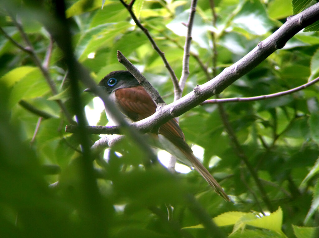
Within the proposed airport area itself, we consider that habitat loss will likely result in substantial local-only declines of some widespread and numerous breeding bird species (e.g. Warbling White-eye Zosterops japonicus and Vinous-throated Parrotbill Suthora webbiana) while having less impact on others, like Large-billed Crow Corvus macrorhynchos. Of potential national conservation concern, however, are several areas of high-quality (and nominally protected) forest, and several pairs of more localized breeding species, including Black Paradise Flycatcher Terpsiphone atrocaudata (Figure 9) and Russet Sparrow Passer rutilans, which currently nest within the airport area. These species will lose breeding habitat.
(2) Unhelpful presentation of data and information in the EIASS
Strategic Environment Assessments provide an analytical and participatory approach for mainstreaming and upstreaming environmental and social issues into decision-making and implementation processes at the strategic level (World Bank 2006). MLIT (2023) does not organize information aimed at addressing the Sustainable Development Goals; does not appear to address the current operating income shortfall of several of the nation’s airports; and does not appear even to refer to national inter-ministerial decisions made in the ROK to address biodiversity loss, as contained within the National Biodiversity Strategy.
Instead, MLIT (2023) focuses on the number of birds which should be monitored up to 13km out from the airport as part of national conservation obligations and a future Wildlife Hazard Management Plan. In assessing the environmental impacts of constructing and operating an international airport at closest within c.6- 7km of an internationally important wetland, we advise that one aim of an EIASS should be to evaluate the likely impacts of construction and operation of a new airport on biodiversity at the local, national and global scale through an informed assessment of the current status of species and habitats.
Tables on p. 960 in MLIT (2023) present counts of species (threatened and non-threatened) and of individual birds by survey within each of the three proposed areas, divided into four main columns: (1) within the airport area itself: (2) out to 3km from the proposed airport; (3) 3-8km from the proposed airport; and (4) 8-13km from the proposed airport. Although the number of individuals and species are listed by survey and month, it remains difficult to interpret how many individuals of how many species might be directly impacted by habitat loss and degradation and indirectly impacted by increased levels of disturbance if the airport were to be constructed. This is because MLIT (2023) does not, for example, contain any analysis based on changes in bird abundance in areas where airports similar to this one have been constructed.
In addition, none of the bird counts in MLIT (2023) are put into an appropriate conservation context to enable a scientific assessment of their relative national or international importance. Especially considering the scale and costs of the proposed airport, and the page-length of the EIA report, current biodiversity and other values need to be presented clearly and in full, to allow proper consideration by decision-makers, legal experts, the media and locally communities.
The ROK has acceded to both the Ramsar Convention and the Convention on Biological Diversity. However, there appears to be no reference in sections on birds in MLIT (2023) either to the Ramsar Convention or to CBD and the National Biodiversity Strategy (the cabinet approved response to obligations of the CBD, with its legal basis founded in Article 7 of the Act on the Conservation and Use of Biological Diversity: ROK 2018). Even though the proposed airport will have international flights, there is no reference either to any of the globally-accepted Ramsar Convention criteria used to identify internationally important wetlands; or to percentages of population as used in Criterion 6 of Ramsar (2024). The absence of such information hinders independent review of MLIT (2023) (which is written entirely in Korean) by specialists from outside of the ROK, including e.g., most IUCN members, and most members of Working Groups and Task Forces working through the East Asian-Australasian Flyway Partnership.
Based on national Winter Census Data (MOEK 1999-2023: Figures 10 & 11) and on count data and information presented in MLIT (2023), the Nakdong Estuary while not yet designated as a Ramsar site, clearly meets Ramsar criteria for identifying internationally important wetlands (Ramsar 2024), in that it regularly supports “vulnerable, endangered, or critically endangered species or threatened ecological communities” (Criterion 2); “20,000 or more waterbirds” (Criterion 5); and “1% of the individuals in a population of one species or subspecies of waterbird” (Criterion 6).
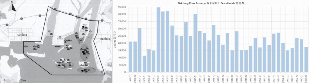
The Ministry of Environment’s Simultaneous Winter Census Bird data confirm that numbers of waterbirds wintering in the Nakdong Estuary have shown a strongly decreasing trend since 2005-2008. Nonetheless, the number of birds present in January 2023 still represented >1% of all birds recorded nationwide during the Census (MOEK 1999-2023) and since 1999, nine species of waterbird have been recorded by the Winter Census in the Nakdong Estuary in Ramsar-defined internationally important concentrations of 1% or more of population. This includes the Nationally Threatened Whooper Swan Cygnus cygnus (NIBR 2019). Not only does the Whooper Swan Cygnus cygnus present a potential bird strike risk (as adult males weigh up to 15kg: Birds of the World 2024), the count of 1,018 in January 2023 represents 10% of the ROK’s wintering population (MOEK 1999-2023, in Kim 2024). The estuary also supports several globally threatened shorebird species during the northward and southward migration periods (see e.g., Moores 2006; Moores 2012); and until recently also supported a large breeding population of nationally Vulnerable Little Terns Sternula albifrons.
At its closest, the proposed runway will reach within 7km of habitat used regularly by several threatened bird species (e.g., globally Vulnerable Steller’s Sea Eagle Haliaeetus pelagicus in winter, nationally Vulnerable Little Tern Sternula albifrons in summer, and globally Critically Endangered Spoon-billed Sandpiper Calidris pygmaea during migration). ICAO (2020) recommend management (and even elimination) of attractants to birds with 13km of an airport. Clearly, the Nakdong Estuary, legally protected as a Wetlands Protected Area, is attractive to birds; and clearly too, the Nakdong Estuary provides quality ecosystems that cannot be replaced or restored at the national level (Principle 1, National Biodiversity Strategy: ROK 2018).
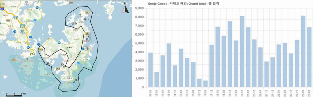
Based on MOEK (2011-2023: Figures 12 & 13), four species of waterbirds have also been recorded in internationally important concentrations of 1% or more of their population along the Geoje Coast too.
In addition, contrary to the holistic planning aims of Strategic Environmental Impact Assessments, tMLIT (2023) fails to address the potential impacts of new infrastructure, including that made public in June 2022 by Busan City, to provide easier access to the proposed airport. The construction of a road bridge across the Nakdong Estuary (Figure 14) to link the proposed Gadeok Do airport to eastern Busan (and north to Ulsan) will, if built, also directly impact bird habitats within the Nakdong Estuary Wetlands Protected Area (Figure 15).

2. Fixed Point Counts
2.1 Methods
Counts of all birds were made on eleven dates from a fixed count point about 25 m above mean sea level (at: 35.010550°, 128.829410°) in Daehang, Gadeok Do, for a total of 64 hours 30 minutes between September 12th 2021 and February 17th 2024 (Table 1). As radar observations were not available, counts started close to dawn and finished close to midday, and were made by scanning the sky with binoculars and a tripod-mounted telescope by the author, supported by Mr. Won Jong-tae and additional observers.
Table 1. Bird Migration Count Effort
| Date | Year | Time of Counts | Period of counts | Observers |
| September 12 | 2021 | 05:55-12:50 | 6hr 55 m | Nial Moores, Lee Seon-Gun, Won Jongtae, You Jung-Il |
| September 18 | 2021 | 06:23: 11:00 | 4hr 37 m | Nial Moores, Won Jongtae You Jung-Il |
| September 24 | 2021 | 06:15-13:45 | 7hr 30m | Nial Moores, Won Jong-Tae |
| October 3 | 2021 | 06:37-13:01 | 6hr 24m | Nial Moores, Won Jong-Tae |
| October 13 | 2021 | 6:25-12:00 | 5hr 35m | Nial Moores, Won Jongtae, You Jung-Il, Lee Seon-Gun |
| November 4 | 2021 | 07:41-12:30 | 4hr 49m | Nial Moores, Won Jong-Tae |
| March 25 | 2022 | 07:15-13:00 | 5hr 45m | Nial Moores, Won Jong-Tae |
| October 15 | 2023 | 07:35-12:50 | 5hr 25m | Nial Moores, Won Jongtae, Kim Hyun-Uk et al. |
| November 7 | 2023 | 07:50-13:50 | 6hr | Nial Moores, Won Jongtae, Kim Hyun-Uk et al |
| November 16 | 2023 | 0720-12:20 | 5hr | Nial Moores, Won Jongtae, Kim Heon Seong |
| February 17 | 2024 | 07:30-14:00 | 6 hr 30m | Nial Moores, Kim Hyun-Uk |
| Time: Grand Total | 64 hr 30m | |||
During our research we aimed to group all of our observations into two overlapping categories:
(1) Birds which appeared to be undertaking active migration or appeared to be resident locally = “total numbers of birds” (a valuable metric in an assessment of importance to conservation);
(2) The “total numbers of crossings”, i.e., the number of times birds flew across an imagined boundary line of the proposed runway as depicted in Figure 16 (valuable for an assessment of bird strike risk).
Figure 16 depicts imaginary boundaries used for sorting each observation into these two main categories. Dotted lines indicate the approximate maximum range at which we could observe or hear birds, either because of distance or topography. From our fixed count point, we were unable to see the eastern half or two-thirds of the proposed runway; but could see larger species in flight two or more km to the north and northwest of the proposed runway; and birds above the Kukusbong ridge (but not behind it).
Birds which remained at all times within the grey line were counted only once (if at all); and were omitted from the category of “total crossings” as they showed no indication of daily movement or migratory behaviour. Such birds are better detected and counted along transects; and would likely not be present in the area once the proposed airport was constructed.

Birds in flight which were seen to pass inside of the dotted lines were counted once and were added to the total number of birds; and birds which passed south of the red line or north past the green line were considered to have started to cross the proposed runway area. A very few species (mostly Large-billed Crows Corvus macrorhynchos and Oriental Magpies Pica serica) crossed and re-crossed these lines on each survey date. Their direction of flight was usually not noted, but on most dates the height of each crossing was estimated.
On each date, weather conditions were noted (based on personal observations and online information provided by KMA.go.kr); and counts were organised into blocks of time as conditions allowed, to help with assessment of observations and to reduce “double-counting” of species that were considered to be wholly migratory through the area. This was considered helpful, as some birds appeared hesitant to migrate and were observed soaring over a period of several hours before initiating more sustained flight: we aimed to count these individuals only once).
Each bird was identified to species (or to family for those individuals which were too difficult to identify to species in flight, e.g., Large White-headed Gull [LWHG] sp. or cormorant sp.); their general direction of flight was noted; and their elevation of flight was recorded in meters above mean sea level, through estimating the bird’s approximate altitude in relation to the heights of obvious landmarks based on Google Earth imagery and Naver Maps.
2.2 Results
2.2.1 Total Numbers
During the eleven dates of survey a total of 10,978 birds of exactly 100 species (listed in Appendix One) were seen or heard from the count point. Although full species lists were only complied for nine of the dates, after removing double-counted birds, a mean of 1,300 individual birds (range 200-2,531) and of 38 species (range 20-47) were recorded each survey (Table 2),
Table 2. Number of individuals and species recorded during each of the fixed-point surveys.
| Number of Individual birds | Number of Species | ||
| September 12 | 2021 | 310 | 47 |
| September 18 | 2021 | 2531 | 20* |
| September 24 | 2021 | 687 | 41 |
| October 3 | 2021 | 917 | 47 |
| October 13 | 2021 | 1,136 | 44 |
| November 4 | 2021 | 200 | 23* |
| March 25 | 2022 | 1,161 | 43 |
| October 15 | 2023 | 1,023 | 45 |
| November 7 | 2023 | 659 | 43 |
| November 16 | 2023 | 1,577 | 37 |
| February 17 | 2024 | 777 | 40 |
*Full species lists were not compiled.
The five most numerous species or species groups ranked in descending order were Chinese Sparrowhawk Accipiter soloensis (2,445), Brown-eared Bulbul Hypsipetes amaurotis (2,176), “Large White-headed Gulls” (Larus vegae, Larus mongolicus and Larus fuscus taimyrensis, with most individuals not identified to species) (1,108), Rook Corvus frugilegus (734) and Red Crossbill Loxia curvirostra (632).
2.2.2 Birds observed to cross the proposed runway area
A total of 68 bird species (listed in Appendix Two with Risk Estimates) were seen to cross the proposed runway at least 10,993 times in total. Many were watched in steady flight, indicating departure. However, approximately 15% of observations of birds crossing the proposed runway comprised repeat counts of largely resident species. For example, a total of 1,459 observations of Large-billed Crows Corvus macrorhynchos seen crossing the proposed runway probably involved a total of only 40-60 individual birds, many of which flew back and forth over Daehang Village.
Approximately half of the 1,800 recorded observations of birds crossing the proposed runway were single birds and two birds together were recorded 355 times. Between 7-8% of observations were of birds in flocks containing 15 or more individuals, and the three species recorded in largest flocks were Chinese Sparrowhawk Accipiter soloensis (largest flock 1,100 on September 18th 2021), Rook Corvus frugilegus (largest flock 400 on March 25th) and Brown-eared Bulbul Hypsipetes amaurotis (largest flock 150 on October 13th).
The approximate altitude of 10,035 crossings of the proposed runway could be estimated, and were sorted into three main categories (Table 3), with those categories selected because of height above ground of bird strikes presented in Dolbeer et al. (2015) and EASA (2009).
Table 3. Estimated height above mean sea level (in m) of birds seen crossing the proposed runway by date of survey.
| Date | Year | Number of Birds By Date | Estimated height 30-175m above mean sea level | Estimated height 175m-700m above mean sea level | Estimated height >700m above mean sea level |
| September 12 | 2021 | 126 | 62 | 64 | 0 |
| September 18 | 2021 | 2,480 | 92 | 2,078 | 310 |
| September 24 | 2021 | 456 | 201 | 234 | 21 |
| October 3 | 2021 | 612 | 436 | 169 | 7 |
| October 13 | 2021 | 1,079 | 486 | 584 | 9 |
| November 4 | 2021 | 121 | 78 | 42 | 1 |
| March 25 | 2022 | 898 | 91 | 787 | 20 |
| October 15 | 2023 | 1,049 | 867 | 173 | 9 |
| November 7 | 2023 | 584 | 432 | 150 | 2 |
| November 16 | 2023 | 1,478 | 1,196 | 261 | 21 |
| February 17 | 2024 | 1,152 | 1,145 | 7 | 0 |
| Grand Total | 10,035 | 5.086 | 4,549 | 400 | |
Approximately 50 % of birds with estimated heights were first seen in flight and / or remained below 175 m above mean sea level (“amsl”); 45% flew between 175 and 700m amsl; and <4% were seen above an estimated height of 700m amsl. Although we likely missed birds that were flying higher than 1000 m amsl, it confirms that the majority of birds that we saw flying over the proposed runway were at a height where bird strike could reasonably be expected.
We were able to determine the direction of flight of 8,575 individual birds as they crossed the proposed runway (Table 4), with this total likely including a small percentage of “double-counted” birds. Based on a preliminary review of weather conditions some such birds likely reversed direction because they encountered reduced visibility, precipitation or headwinds once they headed southeast out to sea, so returned back to land.
Only two dates were (more or less) within the northward migration period: February 17th and March 25th. On these two dates, 17% and 88% respectively of birds flew either north or northeast, suggesting that, especially on the latter date, the birds were arriving from Japan. During surveys conducted during the main southward migration period in both 2021 and 2023, the vast majority of individuals instead flew South or South-east (i.e., towards Teima Do / Tsushima) or West or Southwest (i.e. toward Geoje Do, from where they could either continue heading west, or attempt a crossing toward Japan). A large proportion of birds which flew east (including on February 17th) were gulls, apparently flying toward the outer part of the Nakdong Estuary. Movements of gulls during the main migration periods likely included a mix of birds which commuted between waters off the west and east coasts of Gadeok Do; while others appeared rather more likely to be undertaking migration following the coast, but using the valley as a short-cut.
Table 4. Approximate direction of flight of birds crossing the proposed runway by date of survey
| Date | Year | Number of Birds by Date | S / SE | W / SW | NW | N / NE | E |
| September 12 | 2021 | 95 | 19 | 65 | 1 | 6 | 4 |
| September 18 | 2021 | 2,218 | 1,014 | 1,115 | 3 | 36 | 50 |
| September 24 | 2021 | 380 | 25 | 331 | 16 | 0 | 8 |
| October 3 | 2021 | 570 | 257 | 161 | 10 | 51 | 91 |
| October 13 | 2021 | 1,023 | 428 | 246 | 0 | 328 | 21 |
| November 4 | 2021 | 113 | 25 | 17 | 0 | 29 | 42 |
| March 25 | 2022 | 883 | 3 | 22 | 1 | 780 | 77 |
| October 15 | 2023 | 989 | 586 | 225 | 4 | 163 | 11 |
| November 7 | 2023 | 503 | 32 | 404 | 11 | 16 | 40 |
| November 16 | 2023 | 1,320 | 386 | 722 | 2 | 161 | 49 |
| February 17 | 2024 | 481 | 64 | 63 | 0 | 85 | 269 |
| Grand Total | 8,575 | 2,839 | 3,371 | 48 | 1,655 | 662 | |
Among species’ groups of highest conservation concern and potential for bird strike are diurnal raptors. We recorded a total of 14 species of raptor during the ten dates of survey, with an estimated total of 3,125 individual raptors of 13 species seen crossing the proposed runway (Table 5). This total includes e.g., a small flock of Grey-faced Buzzard Butastur indicus, which first appeared to depart southwest, but then returned back north 35 minutes later presumably because of suboptimal weather conditions for migration.
Table 5. Counts of diurnal raptors made on eleven survey dates organised by species’ highest day count; estimated total number; and the total number of “crossings” of the proposed runway.
| Highest day count | Estimated total number individuals | Total number of crossings | |
| Osprey Pandion haliaetus | 4 | 11 | 11 |
| Crested Honey Buzzard Pernis ptilorhynchus | 3 | 5 | 5 |
| Steppe Eagle Aquila nipalensis | 1 | 1 | 0 |
| Chinese Sparrowhawk Accipiter soloensis | 2,358 | 2,445 | 2,393 |
| Japanese Sparrowhawk Accipiter gularis | 4 | 9 | 9 |
| Eurasian Sparrowhawk Accipiter nisus | 80 | 285 | 295 |
| Eurasian Goshawk Accipiter gentilis | 9 | 22 | 23 |
| Black Kite Milvus migrans | 9 | 16 | 40 |
| Grey-faced Buzzard Butastur indicus | 130 | 209 | 224 |
| Eastern Buzzard Buteo japonicus | 34 | 75 | 75 |
| Common Kestrel Falco tinnunculus | 3 | 9 | 22 |
| Amur Falcon Falco amurensis | 1 | 1 | 1 |
| Eurasian Hobby Falco subbuteo | 3 | 9 | 11 |
| Peregrine Falcon Falco peregrinus | 4 | 10 | 16 |
| Grand Total | 3,107 | 3,125 | |
During the two dates of observation within the northward migration period, raptors arrived from the south or southwest; crossed the proposed runway area quickly, mostly at low altitude, and then used Yeondaebong for soaring and gaining height. In contrast, during southward migration, most raptors appeared to come from the north, and used Yeondaebong to gain height through soaring, with many birds gaining height rapidly so that they were quickly lost to view. On some dates, however, Eastern Buzzards Buteo japonicus and Eurasian Sparrowhawks Accipiter nisus instead appeared to come from the east, crossing low over the outer part of the Nakdong Estuary, before reaching either Yeondaebong or Kuksubong, then soaring to gain height.
2.2.3 Safety Risk
As stated earlier, the safety risk to aircraft posed by bird strike is defined by the ICAO (2020) in Section 3.1.4 as the probability of a strike multiplied by the severity of damage caused. As noted in Section 3.3.2 “the severity scale will depend essentially on the size of the animal and its tendency to flock or congregate. Generally, heavier wildlife and greater flock size increases the probability of damaging an aircraft and impacting its flight performance. Flocking behaviour could include multiple impacts or increase the probability of a strike.”
ICAO (2020) propose various criteria for ranking the safety risk of each species to aircraft, including mass (Table 3.4, 3.3.7) and flocking behaviour (Table 3.5, 3.3.7).
Following this guidance in ICAO (2020) and the advice of two expert ornithologists who have worked for airport authorities to assess bird strike we used our direct observations of birds which crossed over the proposed runway area during the 11 days of fixed counts to identify the level of risk to aircraft. We considered three main variables: the frequency with which we observed them; their flocking behaviour; and their mass.
We allocated 1 point to those species which were only recorded 1-2 times; 2 points to those which were recorded 3-6 times; and 3 points to those species which were recorded seven or more times. We then allocated points based on the largest flock size by species that we observed: 1 point for species seen only as singles or in twos; 2 points for species which we recorded in smaller flocks of 3-14 individuals; 3 points for species which we recorded in flocks of between 15 and 100 individuals; 4 points for those seen in flocks of between 100 and 999; and 5 points for those species found in one or more flocks of 1,000 or more individuals. Based on the upper limit of weight given in the online Birds of the World (2024) we then allocated points to each of the same species according to their mass. The smallest species (weighing <50g) were allocated 1 point; small to medium-sized species weighing between 51g and 150g were allocated 2 points; species weighing between 151g and 1kg were allocated 4 points; and species weighing >1kg were allocated 6 points.
As ICAO (2020) assess damage as probability of a strike multiplied by the severity of damage, we then multiplied the three different point scores for each species, to provide a total “threat level” score for each species (see Appendix Two). Again, to match the presentation in ICAO (2020) which was followed in MLIT (2023) we then assigned a level of risk based on the total points for each species, assessing the risk as Very Low for species which scored 1-5; Low for species which scored 6-20; Moderate for species which scored 20-30; High for species which scored 31-40; and Very High for species which accrued 41 or more points
Based on this process we identified four species as presenting a Very High risk to aircraft; and nine species which we consider present a High Risk (Table 6).
Table 6. Species ranked on the basis of 11 dates of fixed-point counts, to represent the highest risk to aircraft at the Gadeok Do proposed airport.
| Number of Crossings | Largest Flock | Upper Limit of Mass* (g) | Points Total | Risk | |
| Chinese Sparrowhawk | 20 | 1,100 | 204 | 60 | Very High |
| Vega Gull | 127 & large proportion of additional 297 crossings (1 or more individuals) by unidentified Large White-headed Gulls | 15 | 1,368 | 54 | Very High |
| “Taimyr Gull”/ Lesser Black-backed Gull | 124 & small proportion of additional 297 crossings (1 or more individuals) by unidentified Large White-headed Gulls | 30 | 1,200 | 54 | Very High |
| Rook | 7 | 400 | 571 | 48 | Very High |
| Oriental Turtle Dove | 32 | 15 | 274 | 36 | High |
| Mongolian Gull | 65 & small proportion of additional 297 crossings (1 or more individuals) by unidentified Large White-headed Gulls | 8 | 1,580 | 36 | High |
| Great Cormorant / Temminck’s Cormorant | 16 | 3 | 3,700 | 36 | High |
| Grey Heron | 22 | 3 | 2,073 | 36 | High |
| Black Kite | 18 | 10 | 1,080 | 36 | High |
| Grey-faced Buzzard | 21 | 45 | 433 g | 36 | High |
| Eastern Buzzard | 49 | 6 | 1,224 | 36 | High |
| Oriental Magpie | 56 | 28 | 247 | 36 | High |
| Large-billed Crow | 288 | 20 | 1,000 g | 36 | High |
*Birds of the World (2024)
It is important to clarify here that a different point allocation system might reveal different priority species, as would any additional dates of survey conducted through a complete annual cycle as advised by ICAO (2020). Of particular importance too, the analysis presented here, in being based on direct observations and counts of birds crossing the proposed runway area, identifies a different group of species than those presented in the threat assessment in 9-1-1 in MLIT (2023). MLIT (2023) primarily lists waterbirds – presumably because that was the focus of most of the survey and tracking work conducted for the EIA.
2.3. Concluding Remarks
Our surveys confirm that large numbers of diurnal birds (species and individuals) migrate through Gadeok Do, including substantial concentrations of raptors and flocks of both large and small landbirds. It therefore seems likely that many nocturnal migrants will also cross the island (and the proposed runway area) during the main migration periods.
Based on their frequent presence and direct observations of their flocking behaviour combined with their mass, 13 species could be identified as “Very High” or as “High” risk species to aircraft. Two of these species (Oriental Magpie Pica serica and Large-billed Crow Corvus macrorhynchos) appear to be largely resident in the proposed airport area; the majority of individuals of the remaining species are likely either largely seasonal migrants or are complete migrants. In order to try to assess and reduce the impacts of bird strike on aircraft and on bird populations, substantially more research is urgently required on bird migration through Gadeok Do throughout a complete year – before construction of the proposed airport starts. This research should include fixed point counts and targeted bird radar studies (e.g., as outlined by Panuccio et al. 2018).
Again, as stated by ICAO Section 2.2.4.6: “Wildlife surveys should cover the entire year to account for seasonal changes and should also consider different phases of the day.” The assessments provided in MLIT (2023) are currently clearly inadequate. Research for MLIT (2023) was not conducted through an “entire year” and research within the proposed airport area was not designed to adequately evaluate and monitor wildlife hazards (ICAO, Section 2.4.4.2). The level of survey effort within the proposed airport area itself was also somewhat limited in time or scope, as the maximum count of individual birds recorded during any survey was lower than on seven of our 11 dates of fixed-point counts – even though our counts did not include counts within forest or of birds on most of the sea area that will, as proposed, be in-filled during airport construction.
The research in MLIT (2023) did include multiple approaches. However, these research methods did not include “observation points” overlooking the actual proposed runway area to record “behaviour” as advised in ICAO (2020) Section 2.2.4.10 and as advised in the citizen’s opinion; and did not include radar studies of untagged birds.
Instead, MLIT (2023) appears instead to depend largely on tracking birds using GPS telemetry in their efforts to assess direction (and perhaps height) of flight. Fifty individual birds were at the core of this research effort (p. 993-996): two Black Kites Milvus migrans, three Large-billed Crows Corvus macrorhynchos, three Whooper Swans Cygnus cygnus, four Eastern Spot-billed Ducks Anas zonorhyncha and 38 Black-tailed Gulls Larus crassirostris. However, none of these 50 birds were fitted with locators within the proposed airport area itself. Instead, the Black Kites Milvus migrans and Large-billed Crows Corvus macrorhynchos, both of which are partly or largely resident in Busan, were fitted with locators >10km from the proposed airport area; the Whooper Swans Cygnus cygnus and Eastern Spot-billed Ducks Anas zonorhyncha were fitted in the Nakdong Estuary; and the Black-tailed Gulls Larus crassirostris were fitted in late May and June 2023 on Hong Islet, >50km from the proposed airport area. The movements of these birds, while interesting to ornithologists, therefore provide remarkably little insight into any assessment of the risk of bird strike in the vicinity of the airport itself.
Based on the experience of our surveys and guidance in ICAO (2020), an appropriate level of research in preparation of the construction and operation of an international airport on Gadeok Do would, at the very minimum, require all-day surveys by two or three teams of experienced bird researchers within the proposed airport area. Such surveys should be conducted every day throughout the main migration periods (at least from August-November, and again from March to May), and be supplemented by weekly counts in other months throughout at least one entire annual cycle. These fixed point counts should then be combined with targeted bird radar studies, especially if flights are to be made at night-time. These research approaches in turn should be further supplemented by additional tagging of birds on Gadeok Do itself, within the proposed airport area. Finally, research effort also needs to be increased substantially along the Geoje Coast and in the Nakdong Estuary, with detailed mapping throughout the year of daily / nightly and seasonal movements of large waterbirds and diurnal raptors in addition to transect-based mapping of occurrence.
As Busan City failed in its efforts to win the 2030 World Expo, there is no longer any obvious need for urgency to start and complete construction of the proposed Gadeok Do airport. Instead, there is time to conduct appropriate research, in order to reduce impacts on biodiversity and to assess the risks of bird-strike carefully. There is time too to assess the economic viability and social and environmental sustainability of this proposed airport and of those other airports in the ROK that currently run far below capacity. With proper strategic planning, if found suitable some of these other airports could perhaps be used instead to build national flight capacity as part of more balanced regional development. There should also be time to hold more detailed planning discussions with other ministries and local governments and to share forecasts of environmental, economic and social costs of this airport in particular and of other proposed airports with the wider public, as befitting the remit of a genuine Strategic Environmental Impact Assessment conducted within a vibrant democracy.
If adequate research to reduce the risk of bird strike cannot for some reason be conducted; and if threats to biodiversity on Gadeok Do, out to 13km from the proposed airport cannot also be reduced (including to the internationally important Nakdong Estuary and Geoje coast), then it seems wholly appropriate to reconsider the proposal entirely in accordance with Principles 1 and 3 of the Fourth National Biodiversity Strategy (ROK 2018).
The National Biodiversity Strategy was approved by multiple ministries and has its legal basis in Article 7 of the Act on the Conservation and Use of Biological Diversity.
Principle 1 of the ROK’s National Biodiversity Strategy (2019-2023), states that the Stragetgy’s aim is to “Ensure the conservation of quality ecosystems that cannot be replaced or restored (avoid their use in development areas)”; and Principle 3 recommends to “Reject project permit requests or impose restoration fees where restoration or alternative measures are not possible”.
Acknowledgements
Expenses for the research in 2021 and 2022 was supported by a small grant from KFEM; in 2023 research was kindly supported by a local group representative. Sincere thanks to all who participated in the counts, most especially Mr. Won Jong-tae (Dongmyong-Geoje KFEM) who participated in ten of the eleven dates of survey work; and Mr Lee Seon-Gun, Ms. Kim Hyun-Uk and Mr. Kim Heon-Seong. Thanks too to David Melville (in New Zealand), an ornithologist with extensive experience of bird research at airports and Geoff Carey (in Hong Kong), a bird strike specialist advisor to Airport Authority Hong Kong and Airport Authority Macau, who both provided comments which were helpful in improving the text.
References
- Andrews, R., Bevrani, B., Colin, B., Wynn, M.T., ter Hofstede, A.H.M. & Ring, J. 2022 Three novel bird strike likelihood modelling techniques: The case of Brisbane Airport, Australia. PLoS ONE 17(12):e0277794. https://doi.org/10.1371/journal. pone.0277794
- Asian Raptor Network. 2021. Counts of Chinese Sparrowhawk migrating through Southern Tsushima /Teima Do, September 2021. http://www5b.biglobe.ne.jp/~nojiko/watari21.html
- BBS News. 2022. http://news.bbsi.co.kr/news/articleView.html?idxno=3072655
- Birds of the World. 2024. Species Accounts. Cornell Lab of Ornithology, Ithaca, NY, USA.
- Chiatante, G., Panuccio, M., Pastorino, A., Dell’Omo, G., Scacco, M. & Agostini, N. 2022. Small‑scale migratory behavior of three facultative soaring raptors approaching a water body: a radar study investigating the effect of weather, topography and flock size. Journal of Ethology. Published online by Springer in October 2022.
- Cleary, E., Dolbeer, R.A., Wright, S. 2003. Wildlife Strikes to Civil Aircraft in the United States 1990–2002; Federal Aviation Administration, U.S. Department of Agriculture: Washington, DC, USA.
- Dolbeer, R.A., Wright, S., Weller, J.R., Anderson, A.L.& Begier, M.J. 2015. Wildlife Strikes to Civil Aircraft in the United States 1990–2014; Serial Report Number 16; Federal Aviation Administration, U.S. Department of Agriculture: Washington, DC, USA.
- EASA. 2009. Bird Population Trends and Their Impact on Aviation Safety 1999–2008; Safety Report; EASA: Cologne, Germany, 2009.
- Erni, B., Liechti, F. & B. Bruderer. 2005. The role of wind in passerine autumn migration between Europe and Africa. Behavioral Ecology 16:732–740.
- Fernández-Juricic, E., Brand, J., Blackwell, B.F., Seamans, T.W. & DeVault, T.L. 2018. Species With Greater Aerial Maneuverability Have Higher Frequency of Collisions With Aircraft: A Comparative Study. Front. Ecol. Evol. 6:17.doi: 10.3389/fevo.2018.00017
- Gore, M. & Won P-O. 1971. The Birds of Korea. Published by the Royal Asiatic Society.
- Heinänen, S. & Skov, H. 2013. Predicting flight altitudes of birds at OWF based on weather, wind and distance to the coast. Presentation for the the Dansk Hydraulisk Institut (Danish Hydraulic Institute).
- Higuchi H., Ozaki K., Fujia G., Minton, J., Ueta M., Soma M. & Mita N. 1996. Satellite Tracking of White-naped Crane Migration and the Importance of the Korean Demilitarized Zone. Conservation Biology, Pages 806-812 Volume 10, No. 3, June 1996.
- Higuchi H., Pierre, J. P., Krever, V., Andronov, V., Jujita G., Ozaki K., Goroshko, O., Ueta M., Smirensky, S. & Mita N. 2004. Using a Remote Technology in Conservation: Satellite Tracking White-Naped Cranes in Russia and Asia. Conservation Biology, Pages 136–147 Volume 18, No. 1, February 2004.
- ICAO. 2020. Doc 9137—Airport Services Manual—Part 3—Wildlife Control and Reduction, 5th ed.; ICAO: Montreal, QC, Canada.
- Metz, I. C., Ellerbroek, J., Mühlhausen, T., Kügler, D. & Hoekstra, J. M. 2020. The Bird Strike Challenge. Aerospace 2020, 7, 26; doi:10.3390/aerospace7030026.
- Mi C., Møller A. P. & Guo Y. 2018. Annual spatio-temporal migration patterns of Hooded Cranes wintering in Izumi based on satellite tracking and their implications for conservation. Avian Res (2018) 9:23 https://doi.org/10.1186/s40657-018-0114-9
- MLIT (Ministry of Land, Infrastructure and Transport). 2023. Gadeok Do New Airport, Strategic Environmental Impact Assessment. 2240 pages. Published in August 2023.
- MOE. 1999-2023. Ministry of Environment Winter Bird Census (1999-2023) as presented in Kim, A. 2024. Database of Ministry of Environment Winter Bird Census records (1999-2023), accessed in February 2024 at: https://www.andreas-kim.de/MoE/MoE.html
- Moores, N. 2006. South Korea’s shorebirds: a review of abundance, a review of abundance, distribution, threats and conservation status. Stilt 50, 62–72.
- Moores, N. 2012. The Distribution and Conservation of the Avian Biodiversity of Yellow Sea Habitats in the Republic of Korea. Unpublished doctoral thesis, University of Newcastle, Australia.
- NBC (National Biodiversity Centre). 2018. National Biodiversity Statistics of Korea 2017.
- NIBR (National Institute of Biological Resources). 2019. Red Data Book of Republic of Korea, Volume 1. Birds. Ministry of Environment / NIBR.
- Panuccio, M., Agostini, N. Bogliani, G. & Dell’Omo, G. 2018. Migrating raptor counts: the need for sharing objectives and field protocols, and the benefits of using radar. Bird Study, 65:sup1, S77-S84, DOI:10.1080/00063657.2018.1506423
- Ramsar. 2024. The Ramsar Sites Criteria. Accessed in February 2024 at: https://www.ramsar.org/sites/default/files/documents/library/ramsarsites_criteria_eng.pdf
- ROK (Republic of Korea). 2018. The Republic of Korea’s Fourth National Biodiversity Strategy 2019 – 2023. Jointly prepared by the Ministry of Education (MOE), the Ministry of Science and ICT (MSIT), the Ministry of Foreign Affairs (MOFA), the Ministry of Culture, Sports and Tourism (MCST), the Ministry of Agriculture, Food and Rural Affairs (MAFRA), the Ministry of Trade, Industry and Energy (MOTIE), the Ministry of Health and Welfare (MOHW), the Ministry of Environment (ME), the Ministry of Oceans and Fisheries (MOF), the Rural Development Administration (RDA) and the Korea Forest Service (KFS).
- US Department of Transportation, Federal Aviation Authority. 2007. Advisory Circular, Hazardous Wildlife Attractants on or near Airports.
- World Bank (International Bank for Reconstruction and Development / The World Bank.) 2006. Environmental Impact Assessment Regulations and Strategic Environmental Assessment Requirements: Practices and Lessons Learned in East and Southeast Asia.
Appendix One. List of bird species recorded during 11 dates of Fixed-point Counts, Daehang, Gadeok Do (September 2021-February 2024)
| 한글이름 | National Monument # (NBC 2018) | National Conservation Status NIBR 2019) | |
| Whooper Swan | 큰고니 | 201-2 | VU |
| Baikal Teal | 가창오리 | LC | |
| Eastern Spot-billed Duck | 흰뺨검둥오리 | ||
| Mallard | 청둥오리 | ||
| Scaly-sided Merganser* | (비오리 /) 호사비오리 | 448 | EN |
| White-throated Needletail | 바늘꼬리칼새 | ||
| Oriental Cuckoo | 벙어리뻐꾸기 | ||
| Oriental Turtle Dove | 멧비둘기 | ||
| Eurasian Coot | 물닭 | ||
| Great Crested Grebe | 뿔논병아리 | LC | |
| Black-headed Gull | 붉은부리갈매기 | ||
| Black-tailed Gull | 괭이갈매기 | ||
| Common Gull | 갈매기 | ||
| Vega Gull | 재갈매기 | ||
| Mongolian Gull | 한국재갈매기 | ||
| Slaty-backed Gull | 큰재갈매기 | ||
| Taimyr Gull | 줄무늬노랑발갈매기 | ||
| Red-throated Loon | 아비 | ||
| Pacific Loon | 회색머리아비 | ||
| Cormorant sp. | 가마우지 / 민물가마우지 | ||
| Striated Heron | 댕기해오라기 | ||
| Grey Heron | 왜가리 | ||
| Great Egret | 대백로 | ||
| Osprey | 물수리 | VU | |
| Crested Honey Buzzard | 벌매 | NT | |
| Steppe Eagle | 초원수리 (or 흰죽지수리) | (VU) | |
| Chinese Sparrowhawk | 붉은배새매 | 323-2 | LC |
| Japanese Sparrowhawk | 조롱이 | VU | |
| Eurasian Sparrowhawk | 새매 | 323-4 | LC |
| Eurasian Goshawk | 참매 | 323-1 | VU |
| Black Kite | 솔개 | VU | |
| Grey-faced Buzzard | 왕새매 | LC | |
| Eastern Buzzard | 말똥가리 | LC | |
| Oriental Dollarbird | 파랑새 | ||
| Japanese Pygmy Woodpecker | 쇠딱다구리 | ||
| Great Spotted Woodpecker | 오색딱다구리 | ||
| Grey-headed Woodpecker | 청딱다구리 | ||
| Common Kestrel | 황조롱이 | 323-8 | |
| Amur Falcon | 비둘기조롱이 | NT | |
| Eurasian Hobby | 새호리기 | LC | |
| Peregrine Falcon | 매 | 323-7 | VU |
| Minivet sp | 할미새사촌 / 류큐할미새사촌 | ||
| Tiger Shrike | 칡때까치 | ||
| Bull-headed Shrike | 때까치 | ||
| Black-naped Oriole | 꾀꼬리 | ||
| Hair-crested Drongo | 바람까마귀 | ||
| Eurasian Jay | 어치 | ||
| Oriental Magpie | 까치 | ||
| Rook | 떼까마귀 | ||
| Large-billed Crow | 큰부리까마귀 | ||
| Japanese Waxwing | 홍여새 | NT | |
| Coal Tit | 진박새 | ||
| Yellow-bellied Tit | 노랑배진박새 | ||
| Varied Tit | 곤줄박이 | ||
| Marsh Tit | 쇠박새 | ||
| Eastern Great Tit | 박새 | ||
| Eurasian Skylark | 종다리 | LC | |
| Brown-eared Bulbul | 직박구리 | ||
| Light-vented Bulbul | 검은이마직박구리 | ||
| Barn Swallow | 제비 | ||
| Siberian House Martin | 흰턱제비 | ||
| Japanese Bush Warbler | 섬휘파람새 | ||
| Long-tailed Tit | 오목눈이 | ||
| Yellow-browed Warbler | 노랑눈썹솔새 | ||
| Dusky Warbler | 솔새사촌 | ||
| Japanese Leaf Warbler | 일본솔새 | ||
| Kamchatka Leaf Warbler | 솔새 | ||
| Arctic Warbler | 쇠솔새 | ||
| Vinous-throated Parrotbill | 붉은머리오목눈이 | ||
| Warbling White-eye | 동박새 | ||
| Goldcrest | 상모솔새 | ||
| Eurasian Wren | 굴뚝새 | ||
| White-cheeked Starling | 찌르레기 | ||
| Grey-backed Thrush | 되지빠귀 | ||
| Pale Thrush | 흰배지빠귀 | ||
| Dusky Thrush | 개똥지빠귀 | ||
| Grey-streaked Flycatcher | 제비딱새 | ||
| Daurian Redstart | 딱새 | ||
| Blue Rock Thrush | 바다직박구리 | ||
| Russet Sparrow | 섬참새 | ||
| Eurasian Tree Sparrow | 참새 | ||
| Siberian Accentor | 멧종다리 | ||
| Grey Wagtail | 노랑할미새 | ||
| White Wagtail | 알락할미새 | ||
| Olive-backed Pipit | 힝둥새 | ||
| Pechora Pipit | 흰등밭종다리 | ||
| Buff-bellied Pipit | 밭종다리 | ||
| Brambling | 되새 | ||
| Hawfinch | 콩새 | ||
| Chinese Grosbeak | 밀화부리 | LC | |
| Grey-capped Greenfinch | 방울새 | ||
| Red Crossbill | 솔잣새 | ||
| Eurasian Siskin | 검은머리방울새 | ||
| Pine Bunting | 흰머리멧새 | ||
| Meadow Bunting | 멧새 | ||
| Rustic Bunting | 쑥새 | ||
| Yellow-throated Bunting | 노랑턱멧새 | ||
| Chestnut Bunting | 꼬까참새 | ||
| Black-faced Bunting | 촉새 | ||
| Masked Bunting | 섬촉새 |
*Either Scaly-sided Merganser Mergus squamatus or less likely female Common Merganser Mergus mergus.
Appendix Two. Strike Threat Assessment based on 11 dates of fixed point counts, Daehang, Gadeok Do, Busan.
| 11 Dates of Fixed -point Counts | A Observed Number of Crossings | B Observed Flock Size | C Mass | Points calculation | Severity of Risk |
| Number of Points by Attribute | 1 – 2 = 1 | 1-2 = 1 | <50 g = 1 | A X B X C | 1-5= Very Low |
| 3 – 6 = 2 | 3-14 = 2 | 51-200g= 2 | 6-20= Low | ||
| 7 or more = 3 | 15-100 = 3 | 201g-1kg = 4 | 21-30= Moderate | ||
| 101-1000 = 4 | >1kg = 6 | 31-40= High | |||
| >1000 = 5 | >41= Very High | ||||
| Baikal Teal | 1 | 1 | 4 | 1x1X4=4 | VERY LOW |
| Eastern Spot-billed Duck | 1 | 1 | 6 | 1x1X6= 6 | LOW |
| Mallard | 1 | 3 | 6 | 1x3x6= 18 | LOW |
| Scaly-sided Merganser* | 1 | 1 | 6 | 1x1x6 =6 | LOW |
| White-throated Needletail | 2 | 3 | 2 | 2x3x4= 24 | LOW |
| Oriental Cuckoo | 1 | 1 | 2 | 1x1x2 =2 | VERY LOW |
| Oriental Turtle Dove | 3 | 3 | 4 | 3x3x4= 36 | HIGH |
| Eurasian Coot | 1 | 1 | 6 | 1x1x6 =6 | LOW |
| Black-headed Gull | 1 | 2 | 4 | 1x2x4= 8 | LOW |
| Black-tailed Gull | 3 | 2 | 4 | 3x2x4=24 | MODERATE |
| Common Gull | 2 | 1 | 4 | 2x1x4=8 | LOW |
| Vega Gull | 3 | 3 | 6 | 3x3x6= 54 | VERY HIGH |
| Mongolian Gull | 3 | 2 | 6 | 3x2x6=36 | HIGH |
| Slaty-backed Gull | 2 | 1 | 6 | 2x1x6=12 | LOW |
| Taimyr Gull | 3 | 3 | 6 | 3x3x6= 54 | VERY HIGH |
| Pacific Loon | 1 | 1 | 6 | 1x1x6=6 | LOW |
| Great Cormorant | 3 | 2 | 6 | 3x2x6=36 | HIGH |
| Striated Heron | 1 | 1 | 2 | 1x1x4 =4 | VERY LOW |
| Grey Heron | 3 | 2 | 6 | 3x2x6=36 | HIGH |
| Great Egret | 2 | 1 | 6 | 2x1x6=12 | LOW |
| Osprey | 3 | 1 | 6 | 3x1x6=18 | LOW |
| Crested Honey Buzzard | 2 | 1 | 6 | 2x1x6=12 | LOW |
| Chinese Sparrowhawk | 3 | 5 | 3 | 3x5x4=60 | VERY HIGH |
| Japanese Sparrowhawk | 3 | 1 | 2 | 3x1x4=12 | LOW |
| Eurasian Sparrowhawk | 3 | 2 | 4 | 3x2x4=24 | MODERATE |
| Eurasian Goshawk | 3 | 1 | 6 | 3x1x6=18 | LOW |
| Black Kite | 3 | 2 | 6 | 3x2x6=36 | HIGH |
| Grey-faced Buzzard | 3 | 3 | 4 | 3x3x4= 36 | HIGH |
| Eastern Buzzard | 3 | 2 | 6 | 3x2x6=36 | HIGH |
| Oriental Dollarbird | 1 | 1 | 2 | 1x1x4=4 | VERY LOW |
| Common Kestrel | 3 | 1 | 4 | 3x1x4=12 | LOW |
| Amur Falcon | 1 | 1 | 2 | 1x1x4=4 | VERY LOW |
| Eurasian Hobby | 3 | 1 | 4 | 3x1x4=12 | LOW |
| Peregrine Falcon | 3 | 1 | 6 | 3x1x6=18 | LOW |
| Black-naped Oriole | 2 | 2 | 2 | 2x2x2=8 | LOW |
| Oriental Magpie | 3 | 3 | 4 | 3x3x4= 36 | HIGH |
| Rook | 3 | 4 | 4 | 3x4x4=48 | VERY HIGH |
| Large-billed Crow | 3 | 3 | 4 | 3x3x4= 36 | HIGH |
| Japanese Waxwing | 1 | 2 | 2 | 1x2x2= 4 | VERY LOW |
| Coal Tit | 1 | 1 | 1 | 1x1x1=1 | VERY LOW |
| Yellow-bellied Tit | 1 | 1 | 1 | 1x1x1=1 | VERY LOW |
| Eastern Great Tit | 1 | 1 | 1 | 1x1x1=1 | VERY LOW |
| Eurasian Skylark | 1 | 2 | 1 | 1x2x1=2 | VERY LOW |
| Brown-eared Bulbul | 3 | 4 | 2 | 3x4x2=24 | MODERATE |
| Light-vented Bulbul | 3 | 3 | 1 | 3x3x1=9 | LOW |
| Barn Swallow | 3 | 2 | 1 | 3x2x1=6 | LOW |
| Siberian House Martin | 1 | 1 | 1 | 1x1x1=1 | VERY LOW |
| Warbling White-eye | 1 | 2 | 1 | 1x2x1=2 | VERY LOW |
| White-cheeked Starling | 1 | 2 | 2 | 1x2x2= 4 | VERY LOW |
| Dusky Thrush | 1 | 1 | 2 | 1x1x2=2 | VERY LOW |
| Grey-streaked Flycatcher | 1 | 1 | 1 | 1x1x1=1 | VERY LOW |
| Russet Sparrow | 1 | 3 | 1 | 1x3x1=3 | VERY LOW |
| Eurasian Tree Sparrow | 3 | 3 | 1 | 3x3x1=9 | LOW |
| Siberian Accentor | 1 | 1 | 1 | 1x1x1=1 | VERY LOW |
| Grey Wagtail | 2 | 1 | 1 | 2x1x1=2 | VERY LOW |
| White Wagtail | 3 | 1 | 1 | 3x1x1=3 | VERY LOW |
| Olive-backed Pipit | 3 | 2 | 1 | 3x2x1=6 | LOW |
| Pechora Pipit | 1 | 1 | 1 | 1x1x1=1 | VERY LOW |
| Buff-bellied Pipit | 2 | 1 | 1 | 2x1x1=2 | VERY LOW |
| Brambling | 2 | 3 | 1 | 2x3x1=6 | LOW |
| Hawfinch | 1 | 1 | 2 | 1x1x2=2 | VERY LOW |
| Chinese Grosbeak | 2 | 2 | 2 | 2x2x2=8 | LOW |
| Grey-capped Greenfinch | 2 | 1 | 1 | 2x1x1=2 | VERY LOW |
| Red Crossbill | 3 | 3 | 1 | 3x3x1=9 | LOW |
| Eurasian Siskin | 3 | 3 | 1 | 3x3x1=9 | LOW |
| Rustic Bunting | 1 | 1 | 1 | 1x1x1=1 | VERY LOW |
| Yellow-throated Bunting | 3 | 2 | 1 | 3x2x1=6 | LOW |
| Chestnut Bunting | 1 | 1 | 1 | 1x1x1=1 | VERY LOW |